On Saturday, October 28, at the Palazzo della Ragione in Padua, the winning projects of the Bando Periferie 2017 have been announced. Bando Periferie is a competition organized by the National Council of Architects, Planners, Landscapists and Conservatives in partnership with MiBACT General Direction for Art, Contemporary Architecture and Suburbs with the goal of redevelopment 10 urban areas promoting centrality and quality of the project, the participation of local communities and the promotion of young architects: for this reason, it was mandatory to have at least one professionist under35 inside every group.
///
Lo scorso Sabato 28 ottobre, presso il Palazzo della Ragione di Padova, sono stati svelati i progetti vincitori del Bando Periferie 2017, concorso organizzato dal Consiglio Nazionale degli Architetti, Pianificatori, Paesaggisti e Conservatori e dalla Direzione Generale Arte, Architettura Contemporanee e Periferie Urbane del MiBACT avente l’obiettivo di riqualificare 10 aree periferiche promuovendo la centralità e la qualità del progetto, la partecipazione delle comunità locali e la promozione di giovani architetti: infatti, nei gruppi di progettazione era obbligatoria la presenza di almeno un professionista under35.
In this article, we’ll see three of the most interesting among the ten winning projects:
AREA 1 – Barcellona Pozzo di Gotto (Messina)
WINNING PROJECT: “Zolle Urbane” (“Urban Clods”)
TYPE: Urban Design
GROUP: Francesco Messina, Fabrizio Ciappina, Giuseppe Fugazzotto, Gaetano Scarcella, Giuseppe Messina, Cacciamani Agnese, Marco Antonio Messina
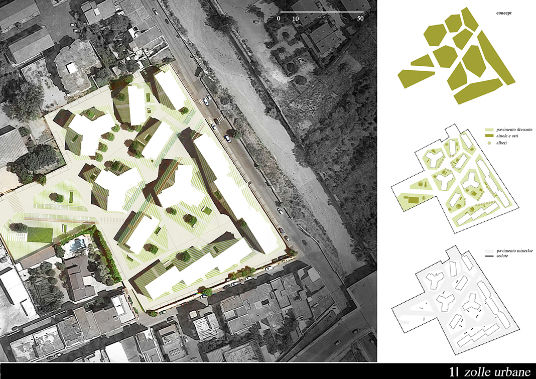
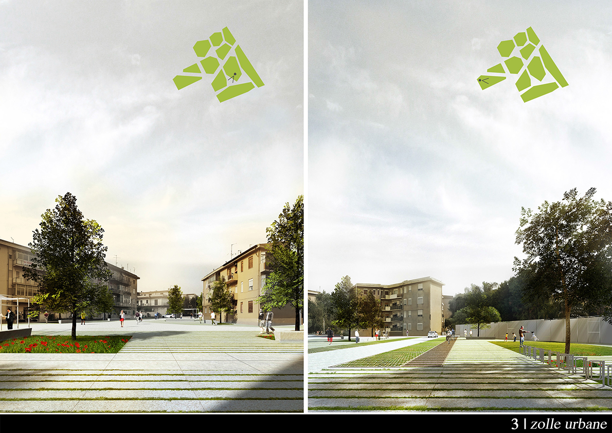
The intervention area, the Via del Mare neighborhood, is characterized by the presence of 3-4 floors residential buildings built after the WWII by the Istituto Autonomo Case Popolare – IACP Institute. The area is adjacent to the Longano torrent, next to which runs the Via del Mare, from which there’s the access to the neighborhood, located a short distance from the city center.
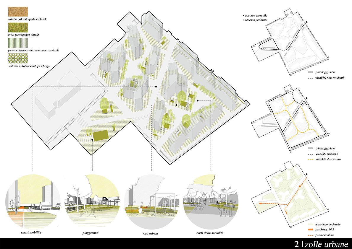
The basic idea of the project comes from the fact that, due to the poor architectural quality of the buildings in the area, the urban space – generated from the location and the shape of the objects – has several elements of interest. The main purpose of the project is precisely the redesign of the parterre; inside the re-thinking of urban space, the current relationship between pedestrian space and carriage space has been reversed: the carriage destination is maintained by the main access road to the neighborhood, assuming the creation of a small inversion pitch near the complex while the remaining part of the ground is destined for public space; in particular the parterre design provides for a first kind of space for pedestrian use that is formally connoted as a series of “islands” from the perimeter – called “clods” (“zolle”) – around the buildings and a second area, located out of the spaces outside the plains, destined once again to pedestrians but with the possibility of transit by residents, visitors and emergency vehicles.
The parking lots are located close to the main carriageway, while on the edge of the road (from access by Via del Mare to the schools) there is a bike lane.
The external fence, which nowadays contributes to generating the image of a neighborhood isolated from the urban context, has been partially re-designed to allow a greater permeability both from the visual point of view, (eliminating the high fence) and from a physical point of view, thanks to the presence of more pedestrian accesses.
The interior space of the neighborhood has been transformed into a fully urban space, however the plots have some elements that have been directly derived from the observation of behaviours and habits typical of the neighborhood residents. In this respect, there were inserted pergolas consisting of light metallic lattices on which hanging curtains and small gardenings.
///
L’area d’intervento, denominata quartiere di Via del Mare, è caratterizzata dalla presenza di edifici residenziali a tre-quattro piani realizzate nel dopoguerra a cura dell’Istituto Autonomo Case Popolari – IACP. L’area è limitrofa al torrente Longano, a fianco del quale corre la via del Mare, da cui si ha accesso al quartiere, e si trova a breve distanza dal centro della città.
L’idea base del progetto scaturisce dalla constatazione che, a fronte della scarsa qualità architettonica degli edifici presenti nell’area, lo spazio urbano generato dalla ubicazione e dalla forma degli stessi presenta diversi elementi di interesse. Lo scopo principale del progetto è da rintracciare proprio nel ridisegno del parterre; nel ripensamento dello spazio urbano si è cercato di invertire l’attuale rapporto tra spazio pedonale e spazio carrabile: la destinazione carrabile viene mantenuta dalla principale strada di accesso al quartiere ipotizzando la realizzazione di una piccola piazzola per l’inversione di marcia in prossimità del complesso scolastico, mentre la restante parte del suolo viene destinata a spazio pubblico; in particolare il disegno del parterre prevede una prima tipologia di spazio ad uso esclusivamente pedonale che si connota formalmente come una serie di isole dal perimetro mistilineo – “zolle”, appunto – attorno agli edifici ed una seconda zona, individuata dagli spazi esterni alle zolle, destinata ancora una volta ai pedoni ma con la possibilità di transito da parte dei residenti, dei visitatori e dei mezzi di soccorso.
I parcheggi vengono collocati tanto in prossimità della viabilità carrabile principale, mentre sul bordo della strada carrabile (dall’accesso da Via Mare alle scuole) è stata delimitata una corsia per la pista ciclabile.
Il recinto esterno, che allo stato attuale contribuisce a generare l’immagine di un quartiere isolato rispetto al contesto urbano è stato parzialmente ridisegnato per consentire una maggiore permeabilità sia dal punto di vista visivo, eliminando la recinzione alta, che dal punto di vista fisico, grazie alla presenza di un numero maggiore di accessi pedonali.
Lo spazio interno al Quartiere di Via del Mare è stato trasformato in uno spazio pienamente urbano, tuttavia le zolle presentano alcuni elementi che sono stati desunti direttamente dall’osservazione delle abitudini e degli usi tipici degli abitanti del quartiere. In riferimento a ciò sono state inserite delle pergole, costituite da leggeri tralicci metallici su cui appendere le tende e dei piccoli giardini.
AREA 6 – Mangone (Cosenza)
WINNING PROJECT: “Trasìre” (“Passing through” in calabrese slang)
TYPE: Architecture
GROUP: Marco Zanolini, Emilia Rosmini, Emiliano Zandri, Antonio Torres Sanz
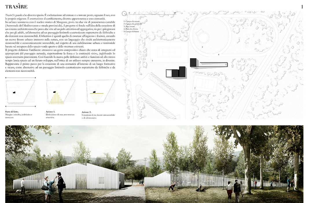
Trasìre! is a word that becomes space. It is an exclamation to come in and find a place for all the people, considering their own needs: it is an exhortation to the change that becomes membership and creates communities. In a clumsy area outside the historical core of Mangone urban area, located between two highway routes (the Mediterranean Highway and the provincial road), the project is based on the idea of creating an architectural system that can become an attractive pole and aggregative for both young and adults, an alternative landscape from the one nowadays characterized mainly by factories and unrecognizable elements, respecting the urban and territorial rehabilitation based on a recovery of open green space and existing structures.
The project defines the environment through a clear compositional gesture that seeks to integrate the natural landscape, respecting its visual strength and continuity, incorporating the pre-existing space built; by doing this, the new skin defines ambiences and functions while, at the same time, giving the way to a future development also with the aim of increasing the use.
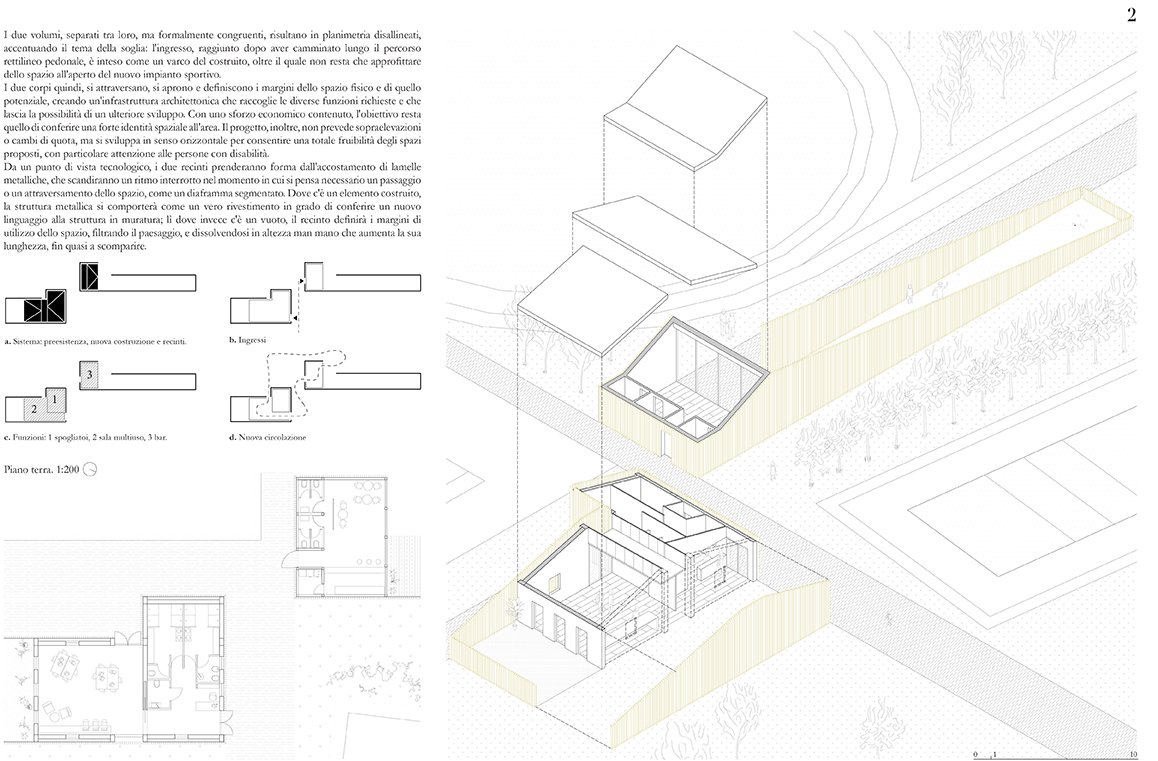
The two volumes, separated from each other but formally congruent, result in misaligned planes, emphasizing the main topic of the “threshold”: the entrance, reached after walking along the straight pedestrian pathway, is thought as a gateway to the built, beyond which it is possible to enjoy the outdoor spaces with the new sport facilities. The two bodies, therefore, cross, open and define the boundaries of physical space, creating an architectural infrastructure that gathers the different functions required and leaves the possibility for a further development.
In addition, the project does not include overhangs or changes in altitude, but it develops horizontally to allow a total usability of the proposed spaces, with a particular attention to people with disabilities. From a technological point of view, the two fences will take shape from the alignment of metal blades that will skip a rupture when a space passage or crossing is thought necessary, such as a segmented diaphragm. Where there is a built-in element, the metallic structure will act as a real coating capable of conferring a new language to the masonry structure; Instead, where there is a vacuum, the fence will define the boundaries of space utilization, filtering the landscape, and dissolving in height as it increases its length, almost disappearing. Slightly off-shore compared to the existing volume, the new cafe will be built in a strategic position: rather central than the tennis, volleyball and basketball fields, it also creates a strong link with the bowls area, bordered in this way by the permeable fence of metal stripes, and with the open-air theater/cinema space, for which the largest number of users is expected.
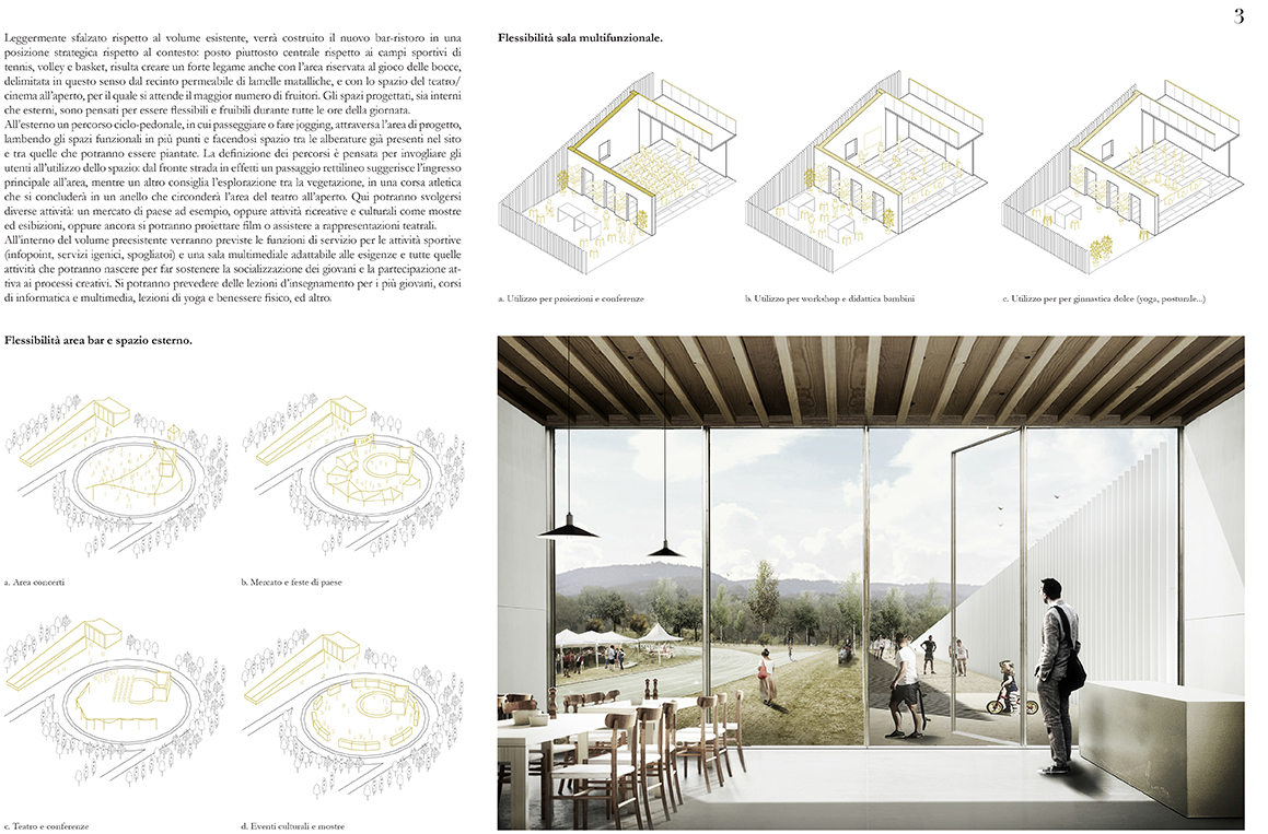
Both interior and exterior spaces are designed to be flexible and enjoyable throughout all the day. Outside, a bike and pedestrian lane crosses the project area, licking the functional spaces in multiple points, making space between the trees already in the site and among those that can be planted. The masterplan is designed to tempt users to use the spaces: from the road front, a straight passage suggests the main entrance to the area, while another recommends exploring vegetation, in an athletic race that will end in a ring that will surround the outdoor theater area. Various activities can take place here: a country market for example, or recreational and cultural activities such as exhibitions or even filming/performing theater performances. Inside the pre-existing volume, the service functions for sport activities (info points, restrooms, changing rooms) will be provided and a multimedia room adapted to all the activities that will be done to support the socialization of young. Here, it will be possible to organize computer and multimedia courses, yoga lessons and physical wellness, and more.
///
Trasìre! è parola che diventa spazio. È esclamazione ad entrare e a trovare posto, ognuno il suo, con le proprie esigenze: è esortazione al cambiamento che diventa appartenenza e crea comunità. In un’area sconnessa con il nucleo storico di Mangone, posta tra due vie di percorrenza carrabile (Autostrada del Mediterraneo e strada provinciale), il progetto si fonda sull’idea della creazione di un sistema architettonico che possa dar vita ad un polo attrattivo ed aggregativo, sia per i più giovani che per gli adulti, un’alternativa ad un paesaggio limitrofo caratterizzato soprattutto da fabbriche e da elementi non riconoscibili nel rispetto di una riabilitazione urbana e territoriale basata sul recupero dello spazio verde aperto e delle strutture esistenti.
Il progetto definisce l’ambiente attraverso un gesto compositivo chiaro che cerca di integrarsi ed appropriarsi del paesaggio naturale, rispettandone la forza e la continuità visiva, inglobando lo spazio costruito preesistente; così facendo, la nuova pelle definisce ambiti e funzioni ed allo stesso tempo lascia spazio ad un futuro sviluppo, nell’ottica di un utilizzo sempre crescente.
I due volumi, separati tra loro, ma formalmente congruenti, risultano in planimetria disallineati, accentuando il tema della soglia: l’ingresso, raggiunto dopo aver camminato lungo il percorso rettilineo pedonale, è inteso come un varco del costruito, oltre il quale non resta che approfittare dello spazio all’aperto del nuovo impianto sportivo. I due corpi, quindi, si attraversano, si aprono e definiscono i margini dello spazio fisico e di quello potenziale, creando un’infrastruttura architettonica che raccoglie le diverse funzioni richieste e che lascia la possibilità di un ulteriore sviluppo.
Il progetto, inoltre, non prevede sopraelevazioni o cambi di quota, ma si sviluppa in senso orizzontale per consentire una totale fruibilità degli spazi proposti, con particolare attenzione alle persone con disabilità. Da un punto di vista tecnologico, i due recinti prenderanno forma dall’accostamento di lamelle metalliche, che scandiranno un ritmo interrotto nel momento in cui si pensa necessario un passaggio o un attraversamento dello spazio, come un diaframma segmentato. Dove c’è un elemento costruito, la struttura metallica si comporterà come un vero rivestimento in grado di conferire un nuovo linguaggio alla struttura in muratura; lì dove invece c’è un vuoto, il recinto definirà i margini di utilizzo dello spazio, filtrando il paesaggio, e dissolvendosi in altezza man mano che aumenta la sua lunghezza, fin quasi a scomparire. Leggermente sfalzato rispetto al volume esistente, verrà costruito il nuovo bar-ristoro in una posizione strategica rispetto al contesto: posto piuttosto centrale rispetto ai campi sportivi di tennis, volley e basket, risulta creare un forte legame anche con l’area riservata al gioco delle bocce, delimitata in questo senso dal recinto permeabile di lamelle matalliche, e con lo spazio del teatro/cinema all’aperto, per il quale si attende il maggior numero di fruitori.
Gli spazi progettati, sia interni che esterni, sono pensati per essere flessibili e fruibili durante tutte le ore della giornata. All’esterno un percorso ciclo-pedonale, in cui passeggiare o fare jogging, attraversa l’area di progetto, lambendo gli spazi funzionali in più punti e facendosi spazio tra le alberature già presenti nel sito e tra quelle che potranno essere piantate. La definizione dei percorsi è pensata per invogliare gli utenti all’utilizzo dello spazio: dal fronte strada in effetti un passaggio rettilineo suggerisce l’ingresso principale all’area, mentre un altro consiglia l’esplorazione tra la vegetazione, in una corsa atletica che si concluderà in un anello che circonderà l’area del teatro all’aperto. Qui potranno svolgersi diverse attività: un mercato di paese ad esempio, oppure attività ricreative e culturali come mostre ed esibizioni, oppure ancora si potranno proiettare film o assistere a rappresentazioni teatrali. All’interno del volume preesistente verranno previste le funzioni di servizio per le attività sportive (info point, servizi igenici, spogliatoi) e una sala multimediale adattabile alle esigenze e tutte quelle attività che potranno nascere per far sostenere la socializzazione dei giovani e la partecipazione attiva ai processi creativi. Si potranno prevedere delle lezioni d’insegnamento per i più giovani, corsi di informatica e multimedia, lezioni di yoga e benessere fisico, ed altro.
AREA 8 – San Mauro Torinese (Torino)
WINNING PROJECT: “The Oscar Niemeyer Park: a park that oxygenates culture and crops”
TYPE: Landscape
GROUP: Annalisa Romani, Monica Sapino
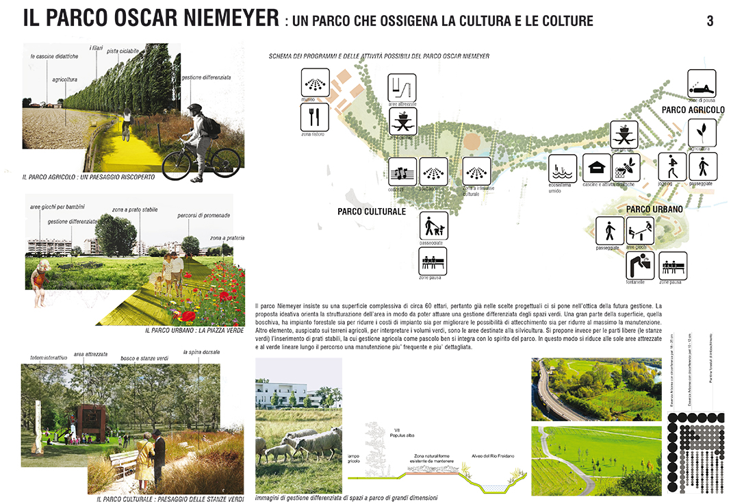
The Niemeyer Park is a park in search of its own identity. The proposal has the ambition to suggest a path of growth and discovery among origins, limits and potential of the area.
Starting from these elements, the aim of the project is to redevelop the area as a new powerful attraction not only for the territory of San Mauro Torinese but for the entire metropolitan area of Turin. The new identity of the Niemeyer Park expresses its strength thanks to a number of innovative products, its identifiability, its structure clearly legible and, at the same time, flexible and adaptable.
The park is thought as a research space, twisting large scale and timely solutions. Its identity is generated around a work on different layers (materials and immaterial): the first is the cultural one, an intangible layer that will be adapted to the evolution of the territory over the time, proposing itself as a dynamic element of the design proposal.
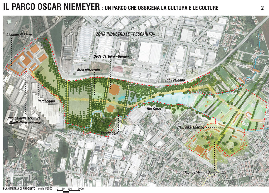
The museums, organized amongst them through the paths of soft mobility and set up with billboards and cooperation programs with the already-established Freidano Ecomuseum, will be the fulcrum of a journey of historical discovery and relaunch of the territory, starting from its architectures and the activities it has supported. In addition to the museum spaces, the main en-plain air equipped space is located near the Burgo building. This “green room” is equipped with extremely spartan furnishings: seats, floor plans and concrete walls that provide space to support the various activities (temporary exhibitions, laboratories, events, outdoor cinemas) from time to time. The area will be equipped also with interactive (totem) wi-fi connection points; these totems are also a milestone along the cycle path and strategic points such as parking lots, bike sharing area, Pragranda urban park and near farms.
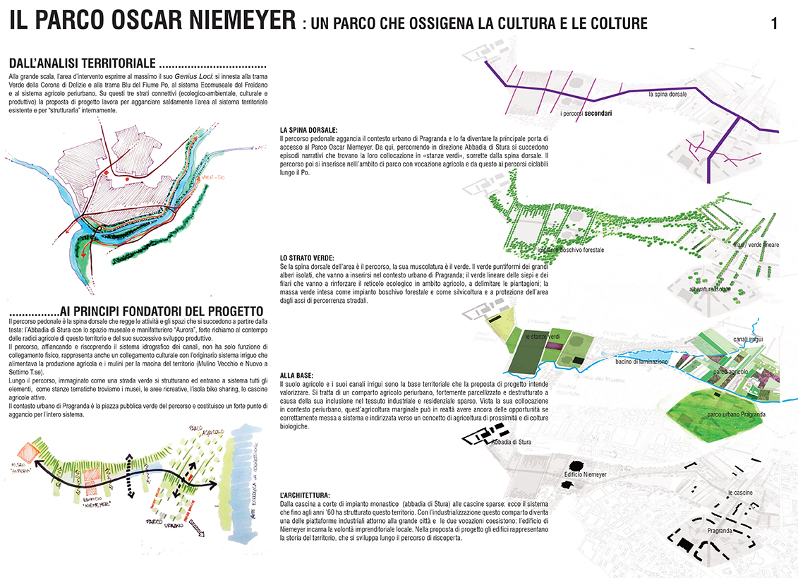
The second layer is green, material, a structural element of the project. Museums, elements create attraction and ties with the territorial scale, are collected in a green box, a layer of dialogue between nature, architecture and production activity. The green layer is a binder, it is the producer of clean air, water and soil serving the inhabitants, visitors, agriculture and consumers of local produces as well as a new production chain of this place. It is structured in woody forests (made with autochthonous, polypeptic and desensitous essences), in rows and hedges (arranged along the water channels, along the boundaries of the agricultural production and along the bike-pedestrian path) and in isolated trees.
The third layer is the conjunction with the goal of generating porosity: scanning in “green rooms”, “green squares” and “green volumes” does not create segments separated by each other but, thanks to the fil-rouge of the bike-pedestrian path, proposes episodes placed in a narrative succession. The park’s backbone, the bike-pedestrian path, forms the connective layer inside the area and allows its connection with the rest of the territory, in particular with the cycling routes existing along the river Po on the left bank and with the VEN-TO cycling path on the right one. In addition, the route is also the element that engages Pragranda urban park and links it to the new Niemeyer Park; in this place, the area reserved for bike-sharing is located. The network of soft mobility, structuring the Park in a capillary way, has the goal of making accessible, visible and secure links related to it such as the museum’s forest, neighborhood agriculture and the Pragranda urban park.
///
Il Parco Niemeyer è un parco alla ricerca del proprio spirito identitario. La proposta ha l’ambizione di suggerire un percorso di crescita e di scoperta delle origini, dei limiti e delle potenzialità dell’area.
Partendo da questi elementi l’obiettivo del progetto è di far risuonare l’area come un nuovo potente elemento di attrazione non solo per il territorio di San Mauro Torinese, ma per l’intero sistema metropolitano di Torino. La nuova identità del Parco Niemeyer esprime la propria forza grazie ad una pluralità di prodotti innovativi, alla sua identificabilità, alla struttura chiaramente leggibile e al contempo flessibile e adattabile.
Il parco è immaginato come uno spazio di ricerca, fatto d’intrecci con la grande scala e di soluzioni puntuali. La sua identità gravita e si genera attorno a un lavoro sugli strati, materiali e immateriali, che lo compongono: il primo è quello culturale, uno strato immateriale che si adatterà nel tempo alle evoluzioni del territorio, proponendosi come elemento dinamico della proposta progettuale.
I Musei, tra loro messi a sistema attraverso i percorsi di mobilità dolce e messi a sistema con cartellonistica e programmi di cooperazione anche con il già affermato Ecomuseo del Freidano, saranno il fulcro vivo di un percorso di scoperta storica e di rilancio del territorio a partire dalle sue architetture e dalle attività a cui ha fatto da supporto. Oltre agli spazi museali, il principale spazio attrezzato en plain air è localizzato in prossimità dell’edificio Burgo. Questa “stanza verde” è attrezzata con arredi estremamente spartani: sedute, piani di appoggio e pareti in cemento che strutturano lo spazio per supportare di volta in volta le più svariate attività (esposizioni temporanee, laboratori, manifestazioni, cinema all’aperto). L’area sarà inoltre dotata di postazioni interattive (totem) per la connessione wi-fi. Questi totem sono collocati a mo’ di pietre miliari anche lungo il percorso ciclopedonale e in punti strategici quali per esempio i parcheggi, l’area per il bike sharing, il parco urbano di Pragranda e in prossimità delle aziende agricole.
Il secondo strato è verde, materiale, un elemento strutturante del progetto. I Musei, elementi che risuonano e che creano attrazione e legami con la scala territoriale, sono raccolti in uno scrigno verde, strato di dialogo tra natura, architettura e attività produttiva. Lo strato verde è il legante, è il produttore di aria, acqua e suolo puliti a servizio degli abitanti, dei visitatori, dell’agricoltura e dei consumatori di prodotti locali nonchè nuova filiera produttiva di questo luogo. Esso si struttura in masse boschive di impianto forestale (realizzate con essenze autoctone polispecifiche e disetanee), in filari e siepi (disposti lungo i canali d’acqua, a margine delle produzioni agricole e lungo il percorso ciclopedonale) ed in alberi isolati.
Il terzo strato è quello connettivo avente l’obiettivo di generare porosità: la scansione in “stanze verdi”, “piazze verdi” e “volumi verdi” non genera settori tra loro separati bensì, grazie al fil-rouge di un percorso ciclopedonale, propone episodi posti in successione narrativa. La spina dorsale del parco, il percorso ciclopedonale, costituisce lo strato connettivo interno all’area e permette il suo collegamento con il resto del territorio, in particolare con i percorsi ciclabili esistenti lungo il Fiume Po sulla sponda sinistra e con la ciclovia VEN-TO sulla sponda destra. Inoltre, il percorso è anche l’elemento che aggancia il parco urbano di Pragranda e lo lega al nuovo Parco Niemeyer, dandogli il carattere di porta di accesso al parco. In questo punto è localizzata l’area riservata alle postazione del bike-sharing. La rete della mobilità dolce, strutturando il Parco in modo capillare, ha l’obiettivo di rendere accessibili, visibili e sicuri gli elementi ad essa collegati come il bosco dei musei, l’agricoltura di prossimità ed il parco urbano di Pragranda.

